
Awards & Nominations
Gale Trail has received the following awards and nominations. Way to go!
Mission to Planet Earth: A Digital History
Gale Trail App
Summary
The Gale Trail App is an interactive educational digital tool that uses gamification to explore hurricanes, their human impact, and their evolution over the years. In this experience players predict the trail of the storm, informed by provided wind speed data. At the end, users receive a score quantifying their success and further information about the hurricane of interest. Throughout the game, users utilize historical context hints to predict the motions of hurricanes. These hints contain real human stories with time and place indicators that aid players in making informed guesses. A live tracking option will allow players to participate in a global community of hurricane enthusiasts.
How We Addressed This Challenge
The Gale Trail App addresses the Mission to Planet Earth: A Digital History challenge by leveraging NOAA data gleaned from satellites built and launched by NASA and presenting them in an interactive game format. The App is further infused with real human testimonials describing lived experiences with specific hurricanes in the first person. When reading these testimonials, the user can picture the exact location this person was when the hurricane hit.
The gameplay challenges the user to guess the hurricane’s track, highlighting the technological accomplishments by NASA and NOAA in creating models in real time. Additionally, the gameplay window features icons of NASA’s geosynchronous satellites that were active in the year the hurricane occurred creating an interactive timeline representing the evolution of NASA’s earth monitoring satellites. Players tap these icons to learn more about each satellite.
In a future iteration of the Gale Trail App, there could be a feature that allows the user to interact with a real-time hurricane and make their own predictions of where the storm will go. Such interactive gameplay promotes curiosity of the work agencies such as NASA and NOAA do and the importance their scientific endeavors have on our everyday lives.
How We Developed This Project
My entire science teaching pedagogy experienced a paradigm shift as a result of the Covid-19 pandemic. As my classes moved online, traditional labs, projects, and lessons were no longer practical. Searching for learner-centered solutions online to aid our study of weather, climate, and storms, the dearth of engaging materials appropriate for remote learning became apparent. A few outdated, flash-based games were tantalizing but incompatible technologically and in breadth. It was this same need for interactive digital tools that I began my foray into iOS app making years ago making several earth science iOS apps to fill the void online.
Inspired to do what I do best as a teacher, to inform, I immediately set about to do just that. Joining my team was my husband, a theater accountant with no science or computer programming experience. Using our combined creativity and technical skills we set about to build a strong working app prototype in the allotted time. Choosing to leverage NASA data was a no brainer for me, as an astronomy enthusiast and teacher. Choosing to focus on hurricanes was also a no brainer. I was no stranger to hurricanes as a kid growing up on a small Caribbean island. The devastating hurricanes Irma and Maria literally hit close to home. Hearing the stories of survivors and seeing the devastation first hand was sobering. Our participation in this hackathon was our attempt to find a way to engage my community in the art of hurricane tracking. Perhaps greater engagement with live hurricanes via a gamified experience would inform islanders of incoming dangers.
With this aim in mind, this app was developed using the Swift programming language and XCode. While I focussed on the technical aspects, my husband, now a fifth grade science expert after sitting through my many remote science classes, took the lead compiling data and content.
How We Used Space Agency Data in This Project
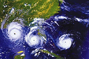
Data and content was pulled primarily from NOAA’s National Hurricane Center and from NASA’s GOES satellite data. Specifically, hurricane coordinates, times, dates, wind speed data, and satellite imagery were collected. Secondary satellite mission facts including historic archival data on timelines and mission histories were also incorporated into the project.
Project Demo
Data & Resources
Hurricane data:
https://coast.noaa.gov/hurricanes/
GEOS Satellite information and images:
Hurricane Hunters plane information and images:
Main Logo photograph:
https://www.nasa.gov/mission_pages/hurricanes/images/index.html
Hurricane forecast process graph:
http://www.hurricanescience.org/science/forecast/forecasting/forecastprocess/
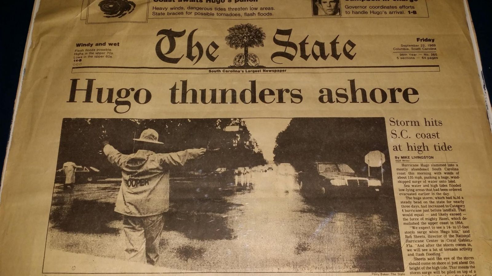
Hurricane stories:
https://www.weather.gov/safety/hurricane-survivors
https://eo.ucar.edu/kids/dangerwx/hurricane2.htm
https://www.northamericanbushcraftschool.com/true-survival-stories-hurricane-hugo/
Images accompanying hurricane stories:
https://eoimages.gsfc.nasa.gov/images/imagerecords/78000/78948/andrew_goe_1982234-236_tn.jpg
https://earthobservatory.nasa.gov/images/90975/barbuda-and-saint-barthelemy-browned-by-irma
https://earthobservatory.nasa.gov/images/9105/hurricane-damage-on-the-bolivar-peninsula
https://www.nasa.gov/sites/default/files/odile_16_september_2014_0917_utc.jpg
https://www.weather.gov/crp/hurricanecarla
https://www.weather.gov/images/ilm/climate/hugo/TheState.jpg