
Fantastic Five| Automated Detection of Hazards
Automated Detection of Hazards
Automated Detection of Hazards
Summary
Australian Bush Fires (under observation). Provided temperature, oxygen level & humidity of a place(near bushfire) our application find out if the area is safe or under grave /moderate level of the impact of fire. We made a web interface to present our project.1.Machine Learning model by Python using Linear Regression algorithm.2.OpenCV for image processing, converting to grey scale images for algorithm to work & find out bright yellow spots as an indicator of bushfire.3.Statistics in CSV file to predict impact & extent.4.Flask, Pickle for backend design.5.Pickling to provide web interface.6.HTML,CSS for frontend.7. Model and web interface connected using Flask.8.Web hosting.
How We Addressed This Challenge
We have made a web interface that will showcase our project and its applications.
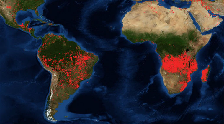
The first thing we have done is a Machine Learning model using Python. The algorithm used in making the model is Linear Regression. Using the OpenCV library in Python we have analyzed and done image processing of the satellite images available from the NASA website regarding Australian Bushfires. Using OpenCV we converted these to grey scale images to help the algorithm work and to reduce model complexity. Then we started detecting the bright yellow spots which is an indicator of bush fire. After detection we converted the images back to normal form. Thus ,we pointed out the affected areas. Once the areas are pointed out we have used mathematical calculation and statistics in the CSV file to predict the impact and extent of fire.We have used Flask, Pickle (modules in Python) for backend design and showcasing our machine learning model in web interface. By using pickling procedure we have provided a web interface to this model in local host server.Through basic HTML and CSS programming we have designed our frontend. This web interface is then connected to our machine learning model by the help of Flask. Using Python we have run the web application and the local server gets activated . Thus the model gets linked and the required output is displayed.
This is important to predict the impact and extent of the fire.
Our project idea is based on the fact that provided the environmental conditions of a place (near the bush fire) such as temperature, humidity and oxygen level, our designed application will find out whether the area is safe from the bushfire or under grave /moderate level of the impact of fire. This will help to predict the impact and extent of the fire.
We have used the satellite images available in the NASA website for image processing and detection of fire.
We have made a web application and it will work if we provide the environmental conditions of a place. For example , we need to provide the temperature, oxygen level and humidity of a particular area and our application will show whether the area is safe , under moderate damage or high extent of damage by the bushfire. For this we have created a Machine Learning model and an user friendly web interface for easy navigation.
We hope to achieve a Machine Learning model which will automatically detect bush fires from satellite images and can also predict its extent. It can also provide warning to the nearby fire stations , thus be able to lessen the damages.
How We Developed This Project
Environmental Hazards has been affecting humanity, wildlife , economy and habitat for ages. But with the advancement of Science and Technology we are trying to lessen its impacts by providing warnings and creating preventions. As Computer Science Engineering students we also wanted to lend our hands in technology and contribute to technological events and advancements. Australian Bushfires are devastating be it the 1851 Black Thursday bushfires, the 2006 December bushfires, the 1974–75 fires that affected 15% of Australia, and the 2019–20 bushfires. It is estimated that the 2019–2020 bushfires led to the deaths of at least 33 people and over 3 billion animals. This a huge loss and we wanted to come up with a solution that can help to at least lessen the impact of such hazard. So we chose this challenge as our project to work on.
We first started on with whatever available data we had in our hands. We got all the required data , satellite images in the NASA website. The reference websites provided has also helped a lot. Then the thing we needed to do was image processing and create a Machine Learning Model that will automatically detect the hazard ,predict its impact and feasibility. So we worked on that. Next what was required was to create a web interface . So we worked on front end and backend. Finally we linked our Machine Learning model with our web interface.
Tools used: HTML, CSS for frontend. Flask for backend. Pickle for showing the model in web interface.
Software used: VS Code, Atom
OS used: Kali LINUX, Ubuntu, Windows, Mac
Our Monzaro OS got crashed while working. We also had to search a lot to get the satellite images. We also faced some problems while linking our machine learning model to the web interface. But finally we made it, which is our achievement and satisfaction.
How We Used Space Agency Data in This Project
We used satellite images from the NASA website to create our machine learning model and detect the impact and extension.Using OpenCV we converted these to grey scale images to help the algorithm work and to reduce model complexity. Then we started detecting the bright yellow spots which is an indicator of bush fire. After detection we converted the images back to normal form. Thus ,we pointed out the affected areas. Once the areas are pointed out we have used mathematical calculation and statistics in the CSV file to predict the impact and extent of fire. This is the concept and work behind our machine learning model.
After our machine learning model is done we moved forward with backend design and web hosting.